While we lived elsewhere, whether it was Oklahoma, Arkansas, or New Mexico, we visited New
Orleans when we could. The city seemed to always be calling us to come back home, and we
kept in touch with some of our friends there through the years. Gene would attend meetings
there, when he could, and later would travel there on business from time to time.
In December 2014 we visited again for several weeks before heading to Brownsville and South
Padre Island for a Christmas holiday. While in New Orleans, we decided to look
for an apartment to rent, planning to winter there, and spend the rest of the year
in Santa Fe. We checked out several places to rent and walked around the area looking
for possible rentals, and ultimately found a great apartment, right next door
to the Air B-n-B at which we were staying. We decided to rent the apartment and move
some of our things down to it early the next year, but as we talked about our plans, and
where to spend the spring and fall, it was clear that New Orleans would be where we spent
most of the year. After a year of splitting our time between the two cities, we made the
move to New Orleans as our primary home in 2016 and got our Santa Fe house ready to sell.
Our apartment was in a neighborhood of New Orleans variously known as "mid-city", "Bayou St. John",
and "Esplanade Ridge". It was the lower level of an over-under duplex, and laid out as a
side-hall shotgun. Located on Ursulines Avenue, near Broad Street, it was and easy walk
to grocery stores, pharmacies, coffee shops, the library, restaurants, and entertainment. The
Fairgounds, where Jazz Fest happens, was a few blocks away, Treme, where music and second lines
happen, was across Broad Street, and the French Quarter was about one mile away, an easy walk
down Ursulines or Esplanade, beneath the oaks. The only things we had to drive to were the
several medical centers. We quickly came to know our landlady, who lived upstairs, and most
of the neighbors. New Orleans is really very much like a small town overall, and that is
particularly true in each neighborhood. It is an easy place to live, a friendly place, and
the weather mild enough for our daily walks nearly year-round.
Having moved there in the winter, we delighted in being outside and our walking tours
and the coffee shops. New Orleans has a long tradition of coffee shop culture in which
the venues are meeting places and hang-out spots where customers can spend most of the
day at a quiet table. These days, of course, they are largely populated by people working
remotely on their laptops or phones, studying students, or folks who love to read and
people watch. We fell in the latter category, and also did a lot of knitting in the shops.
We also loved the incredible variety of architecture in the neighborhoods we walked
through, and the color palate of New Orleans homes, derived largely from the Caribbean
sensibility that permeated much of the town. A welcome change from the rather monotonous,
if "quaint" Pueblo Revival style in shades of brown characteristic of Santa Fe.
Another big difference was the lush foliage of New Orleans, with flowers blooming nearly all
year round. The frequent rains kept things lush and the plants needed to be controlled, not
coddled. And if you did want to water your plants or lawn, there were no restrictions on
water use other than the limits of your wallet. But we did miss the deep blue cloudless
open sky and the stars at night. These are less visible in New Orleans due to the clouds
and the houses and the vegetation.
How to know were you are when you are in New Orleans
To us, New Orleans has always been synonymous with Orleans Parish. In Louisiana, a
Parish is like a county in most other states. Orleans Parish is the central, oldest,
and most densely populated part of greater New Orleans. It also has the highest
proportion of African Americans and families living in poverty. Orleans Parish
is the place where most of the traditions which define New Orleans developed and
flourished and continue to evolve. Orleans Parish lies on both sides of the Mississippi
River and includes
very old neighborhoods across that river from the main part of the city. There were
multiple ferries connecting the two parts of the city until the "Crescent City Connection"
was opened in 1958. It was the first bridge crossing the Mississippi in Orleans Parish,
the Huey P. Long
Bridge in Jefferson having been built in 1935. Again, Orleans Parish was last in line
for state money. The Crescent City Connection added a second span in the 1980s and
is now one of the most traveled bridges in the nation.
The part of the city lying across the river from the main city is known as
the "West Bank", probably because it lay to the right side and was generally to
the west as a ship or boat descended the river. The Crescent City Connection joins
the main city to the "West Bank", which is actually to the east because of the curving
course of the Mississippi River. So actually, traffic traveling on the bridge
toward the "West Bank" are on Route 90 West, but are driving eastward. When driving
toward central city New Orleans, on Route 90 East, you are driving west. To
further confuse the newcomer, as you exit the bridge onto General DeGaulle
Avenue on the "West Bank", you are given the option to drive east or west. In this case,
if you are going to the West Bank, you take the Avenue to the east. And vice versa.
From the immediate post WW2 period through the 1970s, Orleans Parish lost population
and tax revenues as the surrounding suburbs developed and white residents fled to
the new residential developments, largely inaccessible to African Americans for
many reasons, including redlining. The adjacent Parishes, Jefferson to the west
and south, St. Bernard to the east and south, Plaquemines to the south and east,
and St. Tammmany north across the Lake grew in population and to this day remain
largely white. As the city itself lost population, businesses, and revenue, it
fell on hard times. Formerly the city would have been able to annex growing suburbs.
That is how it grew in the 19th and early 20th centuries. But the conservative
(white) state legislature ruled that out and generally opposed any legislation
that would be good for New Orleans. Despite the fact that the legislators and
other governmental figures (think governor) spent a lot of time partying
in New Orleans. The highway from Baton Rouge to New Orleans was, for a time, the
best road in the state, before the Interstate system reached Louisiana.
We first lived here in the days when the chokehold on the city held by
the surrounding white, conservative,
areas nearly starved the city to death and crime and violence increased with
the increasing poverty. So we have a problem with people living in these suburbs
claiming to be from New Orleans, as they usually do. And we always ask "what
neighborhood?".
Living in New Orleans requires a sense of humor and a resident soon develops a
ambiguous, love-hate, relationship with the city. It helps to know the history of the
city, and even more the history of various neighborhoods and "wards" in the city. Knowing
the history does not always bring understanding of how things are, but it provides
a sort of comfort knowing that things have always been as paradoxical as they are today.
In the matter of directions, for example, the ordinary compass points of north, south, east,
and west are of little use in a "Crescent City" that curves along the several bends of
the Mississippi River, between it and Lake Pontchartrain, the former "back" of the city.
The cardinal directions here are "uptown" (upriver), "downtown" (downriver), "riverside", and
"lakeside". A specific business might be thus located on the "downtown, lakeside corner
of Broadway at St. Charles". Which is where the K&B was located when we lived in the
University area.
To further confuse things, you also have to know that "uptown" and
"downtown" have another meaning and refer to the division of the city into the
"American" uptown, upriver from Canal Street, and the "French" downtown, downriver from
Canal Street. This latter distinction is particularly relevant when talking about
the Mardi Gras Indians or the history of the commercial center of the city or of
Storyville.
Because New Orleans is a city of neighborhoods, there are also other ways to designate
a part of town. "Wards" are still commonly used to identify areas and are derived from the old voting
districts developed in the 19th century, which evolved over time as the city grew and
populations changed. "Districts" are also
separate geographic designations, largely based on policing areas and other city functions.
And within wards, and sometimes overlapping them, there are popular names for specific
neighborhoods. "Black Pearl" is a neighborhood within the Uptown/Carrollton Area, for example.
There are many other neighborhoods similarly recognized by the Planning
Commission bearing names chosen by or evolved through usage by residents.
"Holly Grove" is another neighborhood in the Carrollton/Uptown area. "Holy Cross" is in the
lower Ninth Ward. "St. Roch" is in the upper Ninth Ward. "Treme" lies just "above" (lakeside)
of the French Quarter and shares its uptown (Canal Street) and downtown (Explanade Avenue)
boundaries with the Quarter, and is bounded riverside by Rampart Steet, and lakeside by Broad
Street. Originally
called "Back of Town", Treme is partly in the 5th Ward and partly in the 6th Ward. It
is also in Mid-City. You get the picture.
Historically, the Franco-Creole population generally lived downriver of Canal Street.
These neighborhoods were the French Quarter, the areas along Bayou Road/Esplanade Avenue
toward Bayou
St. John, the faubourgs Treme and Marigny, and "outskirts" further downriver.
The incoming American population generally lived (and worked) upriver of Canal, in
the Faubourg St. Mary (dubbed the "American sector" or "quarter" and later the "Central
Business District") and the new suburbs (faubourgs) further upriver, created as the
former plantations were divided and developed to accomodate the growing population.
Incoming immigrants settled where the could and often ended up clustered between
the high ground along the river and the more prosperous areas along the Carrollton
Railway, now the St. Charles Streetcar route. They created neighborhoods, often
settling close to their work, especially along the riverfront.
New Orleanians of African descent including
the Free People of Color and mixed race Creoles, tended to stay in the "downtown"
Faubourgs, in the early years of the city's development and expansion after the
Civil War. Later, as the city expanded up river, African-Americans
populated the margins of the new American
neighborhoods, from the Faubourg St. Mary all the way through the new cities of Lafayette,
Jefferson, and Carrollton.
Initially, because of the rivalry and enmity between the old Creole (French/Spanish)
and the new Anglo (American) populations,the city divided itself into three semi-
autonomous "municipalities": The first was the Creole area from Canal Street to Esplanade
Avenue, the second was the Amerian quarter from Canal Street to Felicity Street, which was
up river boundary of the city, and the third was that part of the city downriver of
Esplanade Avenue, the new Faubourg Marigny and sparsely populated areas downriver
from the French Quarter.
Since each municipality had its own government, the system
was inefficient at best, and was abandoned in 1852, around the time the city
was further expanding. The "municipalities" were simply renamed "Dictricts", with the
First, Second, and Third District being born. A Fourth District was also created, to encompass
the annexed City of Lafayette, taken from the neighboring Jefferson Parish.
With the creation of the Districts also came the "Wards". The
Wards were to extend from river to "back of town", but the delineation was
complicated by the need, for voting purposes,to equalize populations in each of the wards,
and
the order of the numbering was also complicated by the city expansion up river beyond
it former boundary, Felicity Street, and the later incorporation of areas of the
city across the river on the "West Bank". The Wards were numbered with the first
Ward starting at Felicity street, and continued downriver. The densely populated French
Quarter was divided
into three Wards (4th, 5th, 6th),the Marigny 7th and 8th, while the sparsely populated areas
further downriver were consolidated into a huge 9th ward, extending from the lower boundary
of Faubourg Marigny, Press Street, to the St. Bernard Parish line.
The city then turned back upriver as it grew to continue demarking and numbering Wards
above Felicity Street, Wards 10 and 11 in the former Faubourg Lafayette and later
on, with further annexations of Jefferson Parish, the City created the Sixth
District, with Wards 12, 13 and 14 from the City of Jefferson.
the Fifth District
(Ward 15) is the Algiers neighborhood, on the Westbank, the second oldest (1719) neighborhood in
Orleans Parish. In 1874, when Carrollton was annexed, it became the Seventh
Municipal District, Wards 16 and 17.
To further complicate the Ward system, as the city developed drainage systems and
grew into newly created land
in the former "back of town" swamps and along the lake front, the boundaries of
some of the wards were extended in rather awkward fashion to include these new neighborhoods.
So the strange looking map of New Orleans Municipal Districts and Wards
reflects the piece by piece assembly of the city since 1852 and has remained
largely unchanged since 1880, except for the additions along the lakefront.
The people of New Orleans continue to refer to locations largely by
neighborhood names. Sometimes the names refer to a landmark nearby,
such as "The Fairground Triangle", "Bayou St. John", "Holy Cross", or by business
clusters, as "the Cotton District", "Magazine Street" "Central Business
District", or by perceived ethnic enclaves, such as "Chinatown", "the Irish
Channel", "Little Palermo", or by general locations such as "Mid City",
"Parkview", "Lakeview", and some just acquired names from local usage, such
as "Black Pearl, "Hollygrove", and"Gert Town". These more traditional names
have become standardized in recent times through definitions made by planning
organizations, particularly those involved in zoning and development planning.
In time, you learn where these many neighborhoods are, and, for practical
purposes, the only area which is referred to by its Ward designation, is the
Seventh Ward, the area downriver of Esplanade Avenue to Elysian Fields Avenue.
Although the Seventh Ward includes part of the Fauboug Marigny, the latter is not
generally included when the term Seventh Ward is used. Rather, the term refers
to that part of the Seventh Ward from Rampart to Broad Street, a largely
African American neighborhood which as evolved an identity, culture, and
history similar to
and entwined with that of the Treme. Both areas have been fertile grounds for
development of art, music, and culture in the city.
In short, there really isn't an easy way to comprehend a neighborhood other than
by knowing a bit of history and spending a lot of time in the city,
especially going to neighborhood celebrations and second line parades.
Our relationship with water
If you live in New Orleans, you also have to adapt to the multi-faceted relationships
between the city and water. The
climate is sub-tropical and it rains a lot, particulary in the summers, when most
afternoons have rainstorms, sometimes impressive. In fact, that was a feature of life
n New Orleans that we noticed our first time living here, and learned that if you are out
and about, you need to be close to shelter from the rain by early afternoon or, better yet,
safely situated in the covered patio of a bar or restaurant so you enjoy the rain over a drink
or meal. A tip that may explain the drinking and eating habits and daily schedules
of the residents here.
Because the city gets its water supply from the Mississippi River it has water in abundance
but the water also has an abundance of bad things in it. This part of the lower Mississippi is
known as "cancer alley" for good reasons. There are two water systems in New Orleans, or
more properly, Orleans Parish, one for the main part of the city, and the other for the "West
Bank" part of the city. The West Bank is actually the east bank of the river, but that
is a fact that does not seem to bother folks much. Anyway, because the water supply is for
practical purposes pretty much unlimited, the Sewer and Water Board is pretty casual about
leaks, most of the time. In Santa Fe, a water leak was an emergency, and the city had spent
a great deal of money around the time we lived there installing digital monitors on water meters
to detect leaks and notify the authorities immediately. In New Orleans, a modest water leak
from a household water meter or on the street seemed to warrent a response time measured
in weeks rather than hours.
The only time a water leak constitutes and emergency is if
it is large enough to drop the pressure in the main water lines below a certain level.
The system
has so many small constant leaks, the water pressure must be maintained above a level
necessary to sustain all
the leaks and still keep a positive pressure within the mains. If a big leak drops the pressure
enough that the water pressure in the mains falls below that level, water begins to leak back
into the system, contaminiating the water supply with ground water, and resulting in one
of the frequent boil water
advisories for the affected portion of the city. If one of the main water pumping stations
has a pump failure and a drop in pressure, even larger parts of the city may be boiling water
or drinking bottled water for several days.
Water drainage in the city is also an ongoing issue in how the city's relationship
with water. In the 19th century, a drainage system was developed for the city, but it was
not until the early 1900's, when A. Baldwin Wood, an
engineer with the city, invented a type of axial screw pump specialized to function
in the drainage
system for the city. The pumps were first installed in three pumping stations on Broad
Street, located at the low points of the city. They are low-lift pumps powered by 2,000 HP
electric motors, which are running to this day. Because the Mississippi River at New Orleans is
above sea level the water in the river runs downhill to the Gulf. Lake Pontchartrain, at
the "back" (North) of the city, is directly connected to the Gulf, so it is at sea level.
The drainage system was designed to pump water into canals that drained into the Lake.
The pumps and the systems used in New Oreans were revolutionary for the time. Engineers and
authorities from the Netherlands visited New Orleans to study the system and adapted
the Wood pumps for their land reclamation projects. The Dutch, however, evolved a very
different relationship with their water choosing to co-exist with it rather than treat
it as something to be removed entirely. A difference in approach that became relevant
in the 21st century.
Once the city had installed a drainage system and several pumping stations, it became
possible to drain the water from the swamps and wetlands between the high ground along the
river and the several high ridges near to the lake. Metarie Ridge runs roughly parallel to
the edge of the Lake and connects near the entrance to Bayou St. John with the Gentilly Ridge,
which runs further east, parallel to the Lake, and the Esplanade Ridge, which runs roughly
perpendicular to the two, down to the high ground near the river, which was the French
Quarter. Bayou Road, which runs roughly parallel to Esplanade Avenue, was the portage shown
by Native Americans to the early French Settlers as the dry land route from the Lake to the
River.
In the early days of New Orleans, sailing ships often had trouble locating the
navigable entrance to the River, as the delta had many, many "mouths". It was easier
to find the "Rigolets", the entrance to Lake Borgne, then enter Lake Pontchartrain,
sail into Bayou Saint John,
to offload cargo. From the shores of Bayou St. John, goods would be
tansferred to the new city by portage along Esplanade Ridge.
From the
earliest days of the city, there were homes and businesses along the Bayou and
the portage route to the river. Later
people settled on the high ground nearby, the Ridges mentioned above, a process which
accelerated in the early 1800's. After the Louisiana Purchase, when the "American
Quarter" developed, above Canal Street, wealthy Americans built in the "Garden District" suburbs,
newly created upriver from the commercial downtown, and linked the central city by early
railroads.
Wealthy non-American New Orleanians, those of French or Spanish heritage, the "black Creoles"
of mixed race, and the Free People of Color built along Esplanade Ridge, the "Creole Garden District".
Gentilly Ridge was the site of more modest fishing camps and farms, and developed later.
Draining the swamp and drying out the wetlands in the former "Back of Town"
opened large areas of land for development at a time the city was expanding.
It also began the process of removing water from the water-soaked
soils of the city which resulted in subsidence of large areas of the city.
Gradually, the city evolved a bowl shape, with the high ground along the river
and the lake, and the Ridges, forming the edge of an area that sank even
deeper due to the success of the drainage system. The drainage system adapted
as it needed to add more pumping stations, more canals, and lift water higher
and higher as the city sank.
With each heavy rain storm, New Orleanians get to see the drainage system working, or
not working, as the case may be. The drainage pumps run on electricity generated
by power stations run by the Sewer and Water Board, because the motors powering the
pumps are designed for a different electricity than is otherwise used. The power
generators sometimes fail or need maintenance as do the pumps. Today there are a
total of 120 pumps in 24 pumping stations. Canals no longer drain passively to the
Lake, but
require massive pumping stations for the final lift of the water out of the city,
over tall levees bordering the lake.
The overall pumping capacity of the entire system is said to be over 45,000 cubic
feet of water removed per second. Or, in practical terms, the system can handle
the water from a rain storm at the rate of 1" of rain in the first hour, and 1/2"
per hour there after. Or, in the experience of one living here, when it rains
hard, water accumulates in the streets and enters the drainage system. If the
rain continues, the water in the streets gets deeper, from six inches to several
feet depending on the neighborhood. And then, one can watch as the water level
gradually goes down. If everything is working.
All dependent, of course, on functioning pumps, pipes, and "catch basins". Catch
Basins are the point of entry into the drainage system. They are everywhere in the city.
There are over 65,000 of them, and they are not the responsibility of the
Sewer and Water Board, the folks who maintain the pipes and pumps. The are the
responsibility of the Public Works Department. Another city agency entirely. And
perhaps inter-agency cooperation and coordination is not as smooth and effective
as we might hope in New Orleans.
After some spectacular street flooding in August of 2017, and weeks of finger pointing
and changing explanations, the city began to seriously look at the drainage system
function. Pumps failed or were down for maintenance. Power generators the same.
And catch basins had not been maintained or even checked for years, if ever. Catch basins
get plugged with tree roots and debris, are shifted and broken by subsiding soil
and fractured sidewalks. And in one spectacular example, catch
basins in one small part of the city, on one steet (St. Charles Avenue), for a
distance of five blocks (Poydras to Canal) yielded 46 tons of Mardi Gras beads,
when cleaned later in 2017. Continuing clean up the next years yielded in 2019
an automobile (Mazda 626) missing since Katrina in 2005, various other parts of
car chassis, and general
debris, retrieved from one major drainage canal, the Lafitte canal, at the entry
into Bayou St. John.
So you can begin to appreciate why New Orleanians are surprised by few things.
The continuing subsidence of the soil beneath most of the city also contributes to the
renowned New Orleans potholes. Streets in poorer neighborhoods and streets that are not
thoroughfares tend to get maintenance and repair later or never. The potholes can be
merely annoying - the sort of thing that bends wheels, re-aligns suspensions, and
throws passengers about - to prodigious cavities that can swallow half a vehicle. The
response of the Department of Public Works is most generally to place a traffic cone in
the hole to alert oncoming traffic to the danger. Since potholes are living things that
grow and deepen constantly, disappearing traffic cones are also a fact of life here.
The cause of the potholes also makes the repair of the larger one a major undertaking.
Streets seem always to be torn apart for utility work, drainage system repair, or
resurfacing. And, as one might expect, when a residential street's potholes are
finally repaired and the street resurfaced, complaints about the increased traffic
and faster traffic replace complaints about the potholes.
Our relationship with trees
Sidewalks are not much better off than the streets here. Ground subsidence affects the
sidewalks, too, but more so the roots of the trees that shade our streets and homes.
Especially the live oaks. But the oaks are dear to the hearts of New Orleanians and
are to be preferred to level sidewalks. At least in the more prosperous neighborhoods.
Live Oaks are treasured for their age, their spreading branches and the shade they
provide on hot, sunny, summer days.
They are ecosystems unto themselves, supporting a
wide range of plants, some parasitic, some not, as well as insects and small animals of
many kinds. In stretches of Esplanade and of Ursulines, they are also roosting areas
for the Black Crested Night Herons, displaced by Katrina from their usual roosting
sites in coastal areas. The herons are large, heavy, somewhat ungainly birds that
primarily eat small shellfish and crustaceans in the shallow waters, and can make do
with what they find in Bayou St. John and nearby lake shores. Their nests are large
and the progeny clumsy and slow to develop flight, so many die on the streets beneath
the oaks. The birds also produce prodigious amounts of droppings making long stretches
of the streets "no parking" areas, except for the unwitting.
The huge trees are old, often 200 years or more, and suffer damage from storms as well
as invasions by roaches and termites. They need to be trimmed away from power lines and
also trimmed of dead and infested wood. There is little money available to care for
the oaks, so they are often at risk of removal and neighborhoods often rally to save the
trees in their part of town.
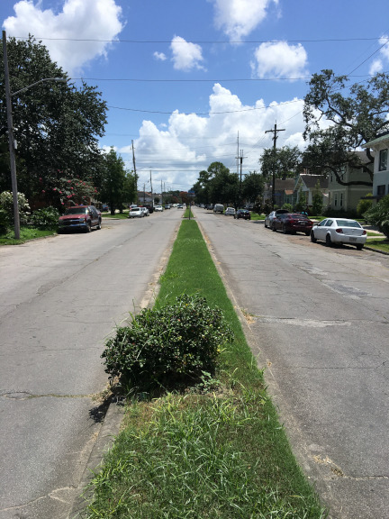
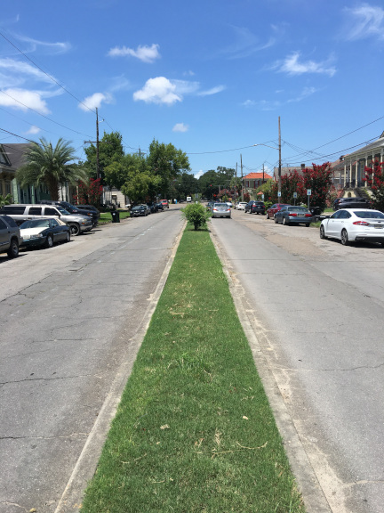
Oaks in areas of largely African American populations are more at risk of removal, and
many of those neighborhoods are without shade trees and completely lacking any of the
live oaks that once lined their streets. Contrast the oaks of Ursulines Avenue
above (lakeside) of Broad, in Bayou St. John, with those below (riverside) of Broad, in
Treme. What a difference one block makes.
Ursulines Avenue "above" Broad Street, in Bayou St. John.
Ursulines Avenue "below" Broad Street, in Treme.
Urban renewal removes the heart of Treme
During the crush of "urban removal" in the 1950s and 1960s, when federal funds were used
to build the interstate roadway system and to "renew" blighted urban areas, Treme was
particulary victimized by the process. Interstate 10 was laid out as an elevated fourlane
highway along Claiborne Avenue, the "black wall street" of New Orleans. Claiborne Avenue
runs roughly parallel the river through roughly the middle of Treme, between Rampart
Street on the riverside and Broad Street on the lakeside. In the post reconstruction and Jim
Crow eras, Claiborne had become lined with black owned and operated businesses, the
commercial center where African Americans shopped and partied during the times when
the white commercial center of Canal Street was unavailable to them. At the time the
Interstate 10 route was being planned, the same planners designed an attached loop of the
highway which would turn riverside along the edge of the French Quarter, then turn again to
run along the levee, separating the Quarter from the river before disgorging downtown
into the white commercial center of Canal Street and the adjacent downtown "Commercial
Business District". Both neighborhoods, Treme and the French Quarter protested the planned
highways, but only the Quarter residents prevailed and prevented their portion of the
roadway.
The wide median ("neutral ground") of Claiborne was lined with huge live oaks, as was the
edge of the Avenue, and had become a gathering place for African Americans and other
residents of Treme and the Seventh Ward. From Saturday parties and Sunday family
picnics, to celebrations of all kinds, it was a blocks long gathering place, reaching
from the uptown side of Canal Street, present day Tulane Avenue, all the way to
St. Bernard Avenue, and beyond. It was also the gathering place for brass bands and Mardi
Gras Indians at Carnival time and St. Joseph's day.
The first step in building the elevated highway was removal of those oaks. The second
step was cutting off many of the streets of Treme to build off and on ramps to the
highway. And the third step was the removal or gradual starvation of the many businesses
along the Avenue. Some survive to this day, a reminder of former glory, just as some of
the columns supporting the highway have been painted by street artists to resemble the
oaks they replaced. Other columns are painted with images of important landmarks and people
associated with the glory days of the Avenue and of Treme.
Pretty much all tourists coming to New Orleans tour a cemetery, or at
least get the chance to take a tour. The cemeteries, often called "Cities
of the Dead", a term coined by Mark Twain disparaging the architecture
of New Orleans, refers to the fact that most burials are in above-ground tombs or
vaults, or even in the outside walls of some of the cemeteries. But the
cemeteries also tell a story of the city and the story, not surprisingly, has
a dark side, or several dark sides.
Cemeteries abound in New Orleans and there were many burial sites in the old
city that were relocated or simply built over in the early history of the town.
Revisiting for a moment,the geography and topography of the orginal city and
the surrounding land, remember the "high ground" was located where the frequent
floods deposited sediment which accumulated over time to form well demarcated
"ridges". Perhaps the best known of these is the high ground along the Mississippi
itself, which was that part of the city settled and build upon earliest. Although
it must also be noted that from the first settlement, the residents began to reinforce
and build up the riverside berm to make the levees of today. The other important
ridges were the Metatarie Ridge, the Gentilly Ridge, and the Esplanade Ridge. The
Metarie Ridge lies along the swampland bording the lakes above the early city. It
roughly paralls the river and the lake front curving through present day Metarie
from the west to about the location of City Park and the Museum of Art today.
The Gentilly Ridge similarly runs
along the boundry between lakes and swamp toward the north east, from about the location
of the present day Fairgrounds through the parts of the city named for it and on to
the east. The Esplanade
Ridge originates at about the junction of the other two ridges and runs to the
southeast to the river. This ridge is approximately the location of Esplanade
Avenue and Bayou Road today and was the land route from the shore of Bayou St. John to
the high ground near the river, about where Governor Nichols street is today.
This land connection was shown by the indigenous peoples to the early French
settlers, and was used as a portage when the city was mostly supplied from
the Gulf via Lake Borne, Lake Pontchartrain, and Bayou St. John.
As the city of New Orleans grew, the tendancy was to utilize high ground along
the ridges for cemeteries, race tracks, and entertainment venues. Thus today, many
of the largest cemeteries are found on the "ridges". There are multiple
cemeteries located in Metarie, where it is adjacent to Orleans Parish. One of the
Canal Street Streetcar lines runs from the Casino by the river to the Cemeteries in
Metarie, popular tourist destinations thus anchoring both ends of the route.
Near the Metarie cemeteries, within the city limits of New Orleans but also
on the high ground of the Metarie Ridge, is Holt Cemetery,
one of the six cemeteries owned and operated by the city.
St. Louis #3 is on the Esplanade Ridge, near Bayou St. John. Lafayette #1
is in the Garden District, on high ground near the river, across Washington
Avenue from Commander's Palace Restaurant.
Historically, once the city itself had been laid out on the riverside high ground,
demarking roughly today's "French Quarter", the difficult lives of the settlers,
the poor sanitation of the city,
and the frequent epidemics of various diseases made the issue of disposition of
corpses an important one. After a time of burying the dead within the limits of
the city itself, mostly in-ground burials in vacant lots or burials along
the levees or
in open "public" land, in the late 1700's city officials
and the Catholic church recognized that this practice was no longer practical or
possible or safe and around 1789, the Saint Louis Cemetery was established just outside the
city limits, above (lakeside) of Rampart Street. Because this location was removed
from the high ground along the river, in the "suburbs", or "back of town", the land
was lower and the high water table made the construction of above ground tombs a
necessity, as the residents discovered after a few years of in-ground burials. And
floating coffins after rainstorms.
St. Louis Cemetery, later St. Louis Number 1, was initially a Catholic only burial
ground, but before too long, by 1804, Prostestant burials were permitted in the land
immediately adjacent to the original Catholic cemetery. Today, St. Louis #1 and
St. Louis #2 (1823) are the oldest cemeteries still in operation and are owned and
maintained by the Archdiocese of New Orleans.
As the city grew, cemeteries were added in the new neighborhoods and neighboring
towns. Cemeteries were also founded by various organizations to serve special
populations, recognizing the increasing diversity of the growing city. Some
cemeteries of note include the following:
Lafayette #1 Cemetery
Located at 1427 Washington Avenue, (across from Commander's Palace
restaurant) this cemetery was founded in 1833 as a municipal cemetery in
what was then the City of Lafayette, comprising what is today most of the
"Garden District", and the "Irish Channel". Lafayette #1 fills one city block,
is laid out in a cruciform
pattern to permit processions through it, and was non-denominational and
non-segregated
from its early days. It is owned by the City of New Orleans, which annexed the
City of Lafayette in 1852 and took over the cemetery at that time. It is presently
closed to visitors due to significant deterioration of the structures within
and work to repair them.
Lafayette #2 Cemetery
This cemetery is at 2110 Washington Avenue, in a working class
neighborhood, today largely African-American. It was founded in the early 1850s
as a municipal cemetary and is dominated by tombs of organized labor societies,
African-American working class societies, French and German benevolent organizations,
and social Aid and Pleasure Societies.
St. Joseph Cemetery #1
Located adjacent to Lafayette #2 Cemetery at 2220 Washington Avenue, this
cemetery is owned and operated by the Archdiocese of New Orleans.
St. Joseph Cemetery #1, established in 1854 by the St. Joseph German Orphan Asylum
Association for German families
in the surrounding area and to supply income for the
Asylum, which had been opened the previous year by the Sisters
of Notre Dame.
St. Joseph Cemetery No. 1 was laid out in a grid plan with
clearly delineated aisles marked by family tombs and plots, with space in
the rear for victims of yellow fever. After about 20 years of operation, the
cemetery was full and the city gave permission to expand the cemetery into
the block behind it, forming St. Joseph Cemetery #2 in 1873. St. Joseph Cemetery
#2 was also a grid plan with many of the memorials in the form of coping
style monuments.
The Archdiocese of New Orleans acquired it from the Sisters of Notre Dame in 1968.
There was a mortuary chapel, St. Mary's Chapel, within St. Joseph Cemetery #1, a small frame
church originally built in 1844 for the German congregation of the current St. Mary's
Assumption Church on Constance and Josephine streets. The original church was
dismantled, reduced in size and relocated
to the cemetery in 1858 when it was replaced by the existing church.
In 1996, the Chapel was dismantled again and relocated
to 1516 Jackson Avenue to replace an earlier Chapel.
A replacement mortuary chapel was constructed within the cemetery in 1998.
Holt Cemetery
Holt Cemetery is a "potter's field" cemetery located next to Delgado Community College,
behind the right field fence
of the college's baseball facility, Kirsch-Rooney Stadium. The cemetery is named
after Dr. Joseph Holt, an official of the New Orleans Board of Health
(famously involved with city health issues concerning Storyville, the Red-light
district of New Orleans) who officially established the cemetery in the 19th century.
Holt Cemetery is one of the Historic Cemeteries of New Orleans.
The cemetery was established in 1879 to inter the bodies of poor or indigent
residents of the city. Funeral processions to Holt Cemetery were generally around,
rather than through, the city. The original cemetery was 5.5 acres and it was expanded in
1909 to 7 acres. Nearly all of the tombs are in-ground burials. When originally established,
families of the deceased were given ownership of the graves at Holt Cemetery in exchange
for the cost of digging the grave and subsequent maintenance of the plot.
Most of the graves and tombs at Holt Cemetery were not commercially or
professionally produced but were instead fabricated by families of the deceased,
giving the cemetery a strong personal touch.
The cemetery contains the remains of known and unknown early blues and
jazz musicians, including Babe Stovall, Jessie Hill and Charles "Buddy" Bolden.
The battered remains of Robert Charles, at the center of the 1900 New Orleans race
riot were briefly interred there, then dug up, and incinerated by a mob. In 1973,
four victims of the UpStairs Lounge arson attack, Ferris LeBlanc and three
unidentified males, were buried in a mass grave at the cemetery.
The city of New Orleans performed $450,000 in repairs and upgrades to Holt Cemetery
in 2013 and 2014. Some of the graves and tombs themselves remain neglected however.
New burials continue at
Holt Cemetery, and many the graves show evidence of frequent visits and various
cultural artifacts.
Carrollton Cemetery and St. Mary Cemetery
Carrollton Cemetery No. 1, also known as the Green Street cemetery was founded around
1849 as the municipal cemetery for the city of Carrollton.
The cemetery was included in the 1874 annexation of Carrollton to the City of New Orleans.
The cemetery contains many in-ground burials with several aisles
of above-ground tombs.
Carrollton Cemetery is a four-block area
bordered by Adams, Hickory, Birch, and Loweline. Lowerline was the downriver boundary
of Carrollton, separating it from adjacent New Orleans.
It was originally segregated by race. The cemetery reserved one
section for white families, and another, smaller section for black families.
Today, the traditionally white section features more elaborate above-ground tombs,
while the “colored” section features more modest inground copings and open-framed
chambers, reflecting racialized economic inequalities rooted in slavery and racism.
When we first lived in New Orleans (1968) and rented a small shotgun/neighborhood
storefront to use as a stuio, it was located on Birch
Street near the corner with Adams. At that time, the graves in the black family
section had mostly hand lettered wooden grave markers. And the cemetary operators
had a prominent sign in that section stating: "Graves must be kept clean or they will
be reused".
A few blocks away, bounded by Adams, Spruce, Cohn and Lowerline Streets is Carrollton
Cemetery No. 2, or
St. Mary's Cemetery. Originally the property of St. Mary's Nativity Catholic Church,
it was taken over by the City of New Orleans in 1921. It is two blocks in area, half
the size of Carrollton Cemetery No. 1.
While early New Orleans cemeteries are noted for their maze-like and crowded nature,
these later suburban ones imposed an urban grid with main streets, side alleys, and
space between tombs. Carrollton and St. Mary reflect the German ancestry of many
early Carrollton residents and are visually connected to the neighborhood as the
cemetery lacks the high walls that surround most of the older, downtown, cemeteries.
Valence Cemetery
2000 Valence Street, New Orleans, LA 70115
Valence Cemetery (or Valence Street Cemetery) was founded around 1869 as
the municipal cemetery for the suburb of Jefferson. It is divided into four
squares and is home to mostly below-ground burials and coping burials.
Several society tombs remain in this historic landscape. It was originally
segregated by race with the "white" section along Valence Street and the
"black" section behind it.
New Orleans’ iconic aboveground cemeteries are an adaptation to the frequent
flooding that makes burial unsuitable. But the tombs deteriorate in Louisiana’s
extreme weather particularly from the high moisture and the rampant vegetation.
They also face break-ins and vandalism from treasure-seekers. City-owned
Valence is less famous than some of New Orleans’s 42 other graveyards,
so maintaining it hasn’t been anyone’s priority for a long time. The city
does a passable job trimming the grass, but upkeep of the tombs falls to
their owners, the majority of whom have died themselves or otherwise
disappeared over the years.
That leaves it to independent volunteer groups to fix the
crumbling landmarks.
For about five years, we spent a month or two in Santa Fe in the summer, making sure
to be there for the entire Santa Fe Chamber Music Festival, and spending some time
at the Santa Fe Opera both as volunteers in the Costume Shop and attending dress
rehearsals and the occasional performance. This arrangement got us out of New Orleans
for much of the "hurricane season" and let us overdose on chamber music every summer.
But in time, the travel back and forth and the expense of it led us to reconsider the
convenient lifestyle we had. In latter 2019 we decided to relocate to a
"retirement community", Woldenberg Village, in Aliers on the West Bank. We made the
move in December of 2019 and within a few months, the first wave of COVID 19 had the
entire city on its knees with horrifying death and morbidity numbers and a shuddering
economy, dependent on tourism.
The retirement community turned out to be a good place to hunker down during a prolonged
lockdown of the city and an even longer self isolation. We each had our crafts and the
space there to pursue them. Ellen her knitting and stitching and Gene his ship
model building and print-making. We pretty much avoided all social contact, especially
any large group indoor activities and with all the local concerts and music venues closed
down, we did not feel we were losing out on anything much. It was a very productive time
from the craft standpoint. Ellen did a lot of needlepoint and participated in online
classes. Gene build a total of 5 ship models and gradually acquired equipment and
supplies for a very nice printmaking studio.
There is information on Ellen's knitting here
and her needle work here.
If interested in the ship models, start with the
Ship Modeling in General page and
visit the particular model of interest from there.
As time went on, we began to feel the confinement of living in a small closed community. Also
the "independent living" community we were in changed character over the second year we were there
as older and more infirm people moved in. We don't think there was anything unique about the situation
there, and feel the changes were related mostly to the difficulty of an aging population to find
suitable housing and access to assistive services. But as the more able-bodied residents
moved away or suffered declining health and the majority of the residents had significant
physical or cognitive limitations, it became more and more the equivalent of an assisted living
facility. Home health aids and nurses sometimes seemed as numerous as residents in the
community center. Perhaps these changes would not have been a problem for us if we had not
been "confined to quarters" there for two years.
Regardless of the changes in demographics of the resident population, as the city
began to open back up, we wanted to resume our concert-going and long walks to coffee houses
we had enjoyed when we lived on the "east bank". But commuting across the river required a car
and required navigating the bridge, the Crescent City Connection, which was never easy and
sometimes intimidating.
Very soon we missed terribly the events and venues we had so easily attended and as the
symphony concert season announced its resumption, we realized that it would be very difficult
to attend those concerts or any of the other evening programs we enjoyed.
So, after two years in the retirement community we had thought would be our last home, we moved
again. It was a difficult decision, as we had for years considered the "continuing care
retirement community model" to be the ideal one for us. But once we had made the decision and
completed the move, we realized that it was the best for us, and also that the community
we were in had changed around us and no longer met our needs.
We moved to the Bywater neighborhood described sometimes as the "Bohemian" part of New Orleans,
a description that sounds redundant at best. We found a large loft apartment in a converted
mill building that could fit all our stuff - including the craft supplies and equipment.
It proved to be a perfect apartment in a great building in a fine, fun, neighborhood and we loved
being there.
And just like that, we were taking long walks again, visiting coffee shops, small restaurants,
shops, and bars, and going to concerts again.
After another two years, although we loved our perfect home and the neighborhood,
we tired of the ever-longer hurricane season - from April through November. And the increasing heat
of the summer.
Once the Santa Fe Chamber Music Festival started back up, we returned to the high desert for the
music season in 2023, extending
our stay from late June to mid October to avoid the peak storm season. We liked the music and we liked
not worring aboout "tropical depressions" in the Gulf. The kinder weather coupled with New Orleans
becoming more and more politically
and socially isolated within a state becoming increasingly radical and racist and religious, told us it
was a good
time to leave. Things were still pretty fine and it might be possible to ignore the writing on the wall
for a while longer, but we packed up and headed out before the next storm season began in 2024.